Overhead Angles for a Fresh Perspective | Why Aerial Photography Matters
Overhead Angles
Aerial photography speaks to me. As a sports photographer, I longed to get up high above the action, and show the overhead view. Why? Because it tells a broad story. It gives context to a game or event. It cleans up backgrounds, simplifies the often chaotic and cluttered setting of an event. And it brings unexpected results.
The same principles apply in travel, tourism and destination photography. If you’re using pictures to market your town, trail, parks and places, think aerials. The overhead view — now easily achieved for a fraction of what it used to cost — gives you:
- clean, graphic pictures into which you can easily drop text and headlines;
- a big ‘reveal’: uncover for your visitors something they may not have seen before;
- deeper blues from your skies and water;
- context;
- the opportunity, while you’re up there, to take equally-appealing video. Use it on your sites and social media platforms.
- an unusual angle for your oft-photographed sites.
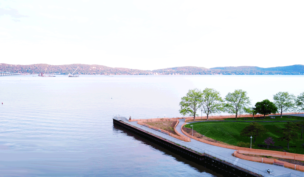
A slight overhead of a waterfront park can give you a clean background for text. Or, take a different and unexpected view for context that can be missing from on-the-ground positioning. This picture of Tarrytown, New York‘s Pierson Park shows a clean, uncluttered scene on which to easily overlay text. The view of the park hasn’t been seen before, and it adds context. It appears to hang out over the river, when in fact the park butts up against it. (I’m in this picture, operating a drone from my seat at a park table in the lower right-hand corner. And that’s how easily we do it!)
The Big Reveal: Show Them Something They Haven’t Seen Before
Recently, while at a New York tourism conference, I spoke to a marketer who told me something surprising. He said that the single thing that drives more people to open his marketing emails is using the word “Undiscovered” in the subject line. And that makes a lot of sense to me.
“Best Undiscovered Wine Trails”! “The Most Secret, Undiscovered Bike Paths in Your State”! “Undiscovered Dirt Roads Through Spectacular Maine”!
I’d open those emails!
I love the explorational side of travel and tourism. I like going where no one else has gone before — even though I’ll seek out the advice of about twenty people who have reviewed it already!
So I apply this principle to my travel and tourism photography. I try to find places in my photography where the undiscovered can be revealed. Whenever possible, I use my drone to capture stills and video for this revealing look at what awaits a traveler.
Examples: How the Aerial Reveals Your Neighborhood, in Context
Overhead shots are perfect for that. For example: this picture of my neighborhood shows a basic street scene. But it reveals so much more: the proximity to the Hudson River. The old-fashioned closeness of the houses (and the implied suggestion that the community is closely-knit). A hilly landscape. Mature trees. It’s a simple difference, but it imparts more than the usual streetscape.
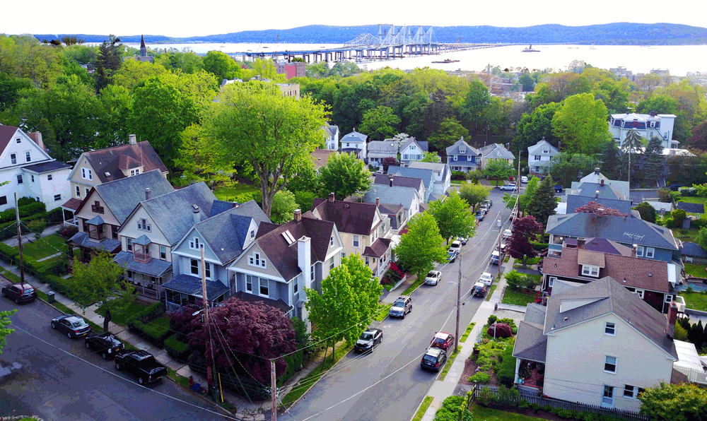
A Tarrytown neighborhood street in early summer. By going aerial, more information is revealed about a place and a time of year, as well as proximity to the river and new bridge.
The picture below shows where an overhead angle reveals something you might not know about a sport. I was shooting the US Open of Golf, and we drifted over the practice tee on the final day of the championship. You could see — but only from the air — how progressive days of firing off tee shots had eroded the grass over the length of the tournament:
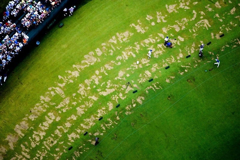
The days of the tournament may be measured by the tracks in the driving range at Winged Foot Golf Club, pictures with a lone golfer practicing his swing. The track closest to the crowd was where golfers practiced driving on Monday, the first day of the tournament.
Keep it Clean.
Speaking as someone who’s laid out a lot of web pages, I appreciate clean pictures. That means graphic pictures with uncluttered backgrounds. And that’s what aerials give you, if done with the final use in mind.
The picture below shows an aerial view that any graphic designer would love! You can use it as a header image, or a two-page spread. Drop that text!
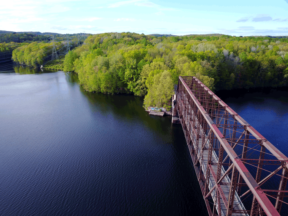
Estuary, Farmington River, Connecticut. The deep darkness of the river, the consistent tone and overall “clean” image makes it easy to overlay your text or headlines. Use this picture in marketing your place, park or waterway.
Context is King.
When you’re advertising your trails, context is everything. An overhead image can say so much more about your corner of the world.
If your trail or bike path weaves through villages, mountains, riverways, or historic sites, try to capture as much of that information in a single picture. Again, this will do the “heavy lifting” for you. You won’t have to tell, you can show.
The picture below shows a view of the North County Trailway, in Westchester County, New York. While most pictures of this spot on the trail are taken from the former railway bridge, this picture rises up a little and shows the reservoir underneath, as well as the hilly and shaded woods into which the trail disappears.
Show it all: the old railway bridge, the reservoir, the woods and the lay of the land. This aerial picture shows a favorite stretch of Westchester County’s North County Trailway.
…And Those Blues!
You may have noticed that overhead angles result in more vivid blues. I’ve found that combining the overhead angle with shooting at both ends of the day have this effect.
I almost never shoot during the day, when the sun is high in the sky. (The exception to this is in winter, when the sun’s angle is typically in a day-long slant.). It’s a rule of thumb for me, and when combined with the aerial photography, the result is electric.
So, whether I’m shooting for you, or someone else is, make sure you ask for (and get) those blues of high angle/early morning/late afternoon.
While I’m Up There, Let’s Make Some Video
You’ve probably been schooled on how important video content is for marketing your destination. I grudgingly concur. The good news is that, if I’m shooting for you, there is no material (or cost) difference in making lovely video for you at the same time as I’m shooting your stills in the air. It’s easy to edit, pretty to look at, shareable and post-able, and it just makes you look good.
Suzy Allman specializes in aerial photography for travel, tourism and destination marketing, as well as for editorial clients. I include aerial photography in outdoor photo assignments, at no additional cost. Contact me, and let’s talk about how we can work together.